 to add an item to your Itinerary basket.

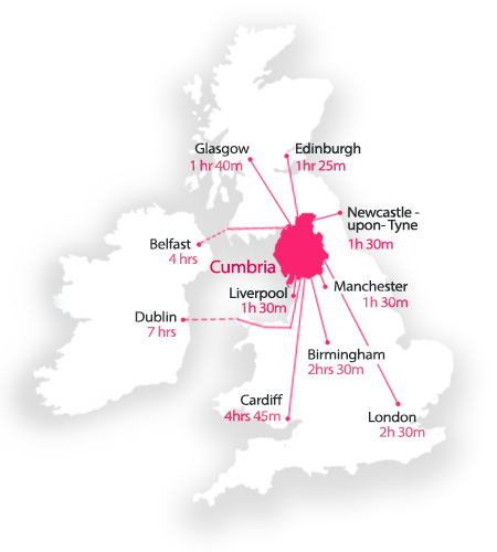
Visit Lake District and Cumbria
The Official Guide to the region
In England’s north western corner lies ancient Cumbria and the timeless landscapes of the Lake District. Home to two UNESCO World Heritage Sites, this is the perfect place to reconnect: with nature, with loved ones, and with yourself. A rich tapestry of lakes, mountains and countryside invites you to explore, while the towns and villages brim with local character.
January is health and wellbeing month in the Lake District, Cumbria. Breathe in the crisp air and blow away the cobwebs. Relax and recharge. Dine on seasonal food and drink in quality restaurants; delve into our unique shops and retail experiences and explore cultural gems. Wrap up for family-friendly winter walks, or head indoors to one of our many weatherproof attractions.Take a look at what’s on, and get inspired.
Prepare for new adventures
Book a break now to beat the rush, whether you’re planning a spring break or a summer getaway. There’s plenty of accommodation: from B&Bs to cosy cottages, romantic hotels to luxury spa resorts, we’ve got it covered in the Lake District, Cumbria.
It’s so easy to plan your visit in advance, with a helping hand from our Know Before You Go guide. We’ve even created some practical tips and recommendations especially for motorhome and campervan users, with our new ‘Van Life’ page.
Looking for some extra inspiration? Check out our great selection of things to do in the Lake District; take a look at our inspirational blog and itinerary planner; or sign up to one of our e-newsletters and get the latest news and special offers from the Lake District, Cumbria, delivered straight to your inbox.
You may leave the Lake District, Cumbria, but once you’ve been, it’ll never leave you.